


Why Severe Weather Is The Thing To Watch For This Spring Season
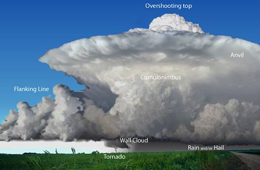
Photo Courtesy of weatherquestions.com
April 27, 2018
It doesn’t seem like it when you look outside lately, but severe weather season is actually under way.
Severe weather season means that the atmosphere is warming after the winter. But the increase in
temperatures and humidity means that sever weather like thunderstorms, straight line winds, hail and
tornadoes.
What is the difference between a watch and a warning?
A watch means that atmospheric conditions are favorable or expected for severe weather, but it is not
occurring. If there is watch, people should keep watching the weather and be prepared to seek shelter.
A Warning means that conditions are occurring or will certainly occur. For a tornado, it means that a
thunderstorm has developed and has produced a tornado, spotted by someone, or radar has indicated
rotation in the storm to prove that a tornado is developed. A severe thunderstorm warning means that
a severe thunderstorm has developed that is capable of producing either hail greater than 1” in
diameter or 58mph wind speeds. People should take tornado or thunderstorm warnings seriously and
should go to cover in a place on the lower level of your home away from windows.
Who declares a weather emergency?
The local National Weather Service office issues weather warnings or watches. The National Weather
Service for Minnesota is close to us is in Chanhassen. The office has 13 meteorologists, 4 hydro-
meteorological technicians, 1 meteorologist intern, 3 electronics technicians, a service hydrologist, an
information technology expert, a facilities technician, and an administrative assistant to run the
instruments that are constantly monitoring the weather. They are open every day, all day long. They
have sophisticated electronic thermometers, rain gauges, snowfall and snow depth boards that they
monitor around the state. They also have state of the art Doppler Radar. You can follow them on
twitter @NWSTwinCities
What are the atmospheric conditions that cause thunderstorms, tornados, hail and straight line winds?
Thunderstorms form when the atmosphere has air in the lower levels that is warm and humid and cool
in the upper layers. When the hot air rises, it hits the cold air. This causes the air mass to start to turns
over violently and create water vapor or convective clouds. This movement of warmer air upward is
called updraft. The air continues to turn over and rise higher and higher in the sky as it develops. Some
thunderstorms are 8 to 12 miles in the atmosphere.
A tornado occurs in a very violent thunderstorm where there is a lot of instability- air turning over
violently- and also where there is wind shear. Wind shear means that wind direction is changing, and
the wind speed is increasing in the higher parts of the storm. For example, there might be a a southerly
wind of 15 mph at the surface and a westerly wind of 50 mph at 5,000 feet high.
Straight line winds also need special conditions of a thunderstorm to occur. Unlike tornadoes, straight
line winds do not have rotation in them. Straight line winds start in the mid or upper level of a
thunderstorm and when they move to lower denser, warmer part of the storm and then the ground,
they burst out violently. They are short but intense “microbursts” of very strong winds. They can last in
a small area from a few seconds to a few minutes. Sometimes the gusts are up to 150 mph.
Hail is caused by thunderstorms where the colder air of the thunderstorm is very higher in the
atmosphere. It is so high in the sky that the air is below the freezing level. And the updraft is also so
strong that it keeps the freezing water from falling to the ground. Sometimes the developing hail is caught in the updraft many times forming ice layers and growing in size before they eventually fall to the
ground.